What is a Secondary City (2C)?
2Cs are the fastest growing urban areas in developing countries, experiencing unplanned growth and development. These cities are unique environments that have generally been poorly mapped with limited data and information on infrastructure, land tenure, and planning. A secondary city is not only defined by population, size, function, and economic status, but by the neighboring and/or distant cities and their socio-economic status. The population of a secondary city may range between 10-50% of the country’s largest city. 2Cs are urban centers providing critical support functions for governance, transportation and production services. A secondary city may emerge from a cluster of smaller cities in a metropolitan region or may be the capital city of a province, state, or second-tier administrative unit within a country.
WHY MAP 2Cs?
Mapping 2Cs for Resiliency and Emergency Preparedness builds local capacity in using open source geospatial technologies to collect important data needed for urban planning and integrated resource management, strengthens local capacity through international partnerships, and creates new data in secondary cities that are frequently data-poor, under-resourced, and lagging behind in the provision of infrastructure and essential services. Mapping these cities is an essential activity in building resiliency and devising robust emergency management plans. Core elements of the 2C project are:
- U.S. Embassy outreach to identify city governments for mapping and imagery analysis partnerships. Working with the twelve regional US Environmental, Science, Technology and Health (ESTH) hubs across the globe, this project facilitates the generation of digital data necessary for planning for urban sustainability
- Long term engagement with partners to build capacity for continued geospatial data development in situ
- Utilization of high resolution satellite imagery for mapping and analysis
- Engagement tools that include ESRI’s ArcGIS and other open source geospatial tools for data generation, analysis, and modeling.
Who are 2C partners?
The 2C Initiative is made up of multiple partners from public and private sectors and are local, regional, and international. The core lead partners include the Humanitarian Information Unit (HIU) in the Office of the Geographer of the US Department of State, the American Association of Geographers (AAG), and Colorado State University. Local partners include non-governmental organizations, universities, and local and regional governments. The Secondary Cities Initiative is expanding to include new cities around the globe. The 2C project has established a partnership with Esri demonstrating the public-private partnership. Esri provides software licenses for ArcGIS and ArcGIS Online accounts for University partners.
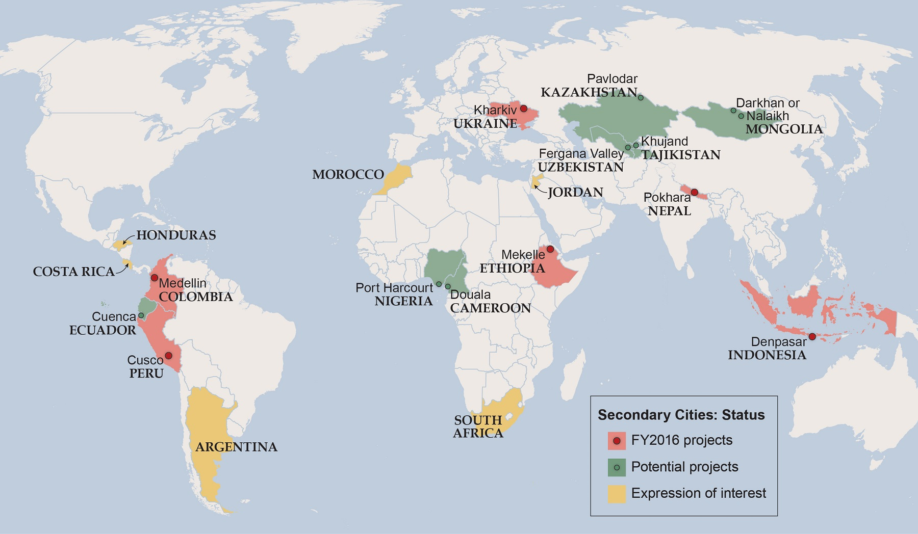
Where are Secondary Cities?
Secondary cities are located around the world. They are on every continent (except Antarctica). Each city faces unique environmental and social challenges that impact future planning, growth, and sustainable development. Place-based needs determine how geospatial technologies will be used for data generation, analysis and visualization.
How are Secondary Cities (2C) selected?
Secondary cities are determined based upon a number of criteria that include:
A scoping trip is conducted to potential cities where the 2C Principle Investigator, REO and ESTH Officers visit local and regional government agencies, universities and non-governmental organizations. These scoping trips assess the capacity of the site to host a 2C project. Multiple meetings from the national to local government levels are planned to discuss key geospatial data needs, data sharing policies, critical issues related to geospatial data collection, and assess local capacity.
- meeting characteristics that define a secondary city
- US Government regional priority
- recommendations by Regional Environmental Officers (REOs) and Environment Science Technology and Health (ESTH) Officers in consultation with the Office of the Geographer and 2C management team based on assessed need for geographical data support and development
- local champion engagement
A scoping trip is conducted to potential cities where the 2C Principle Investigator, REO and ESTH Officers visit local and regional government agencies, universities and non-governmental organizations. These scoping trips assess the capacity of the site to host a 2C project. Multiple meetings from the national to local government levels are planned to discuss key geospatial data needs, data sharing policies, critical issues related to geospatial data collection, and assess local capacity.
Which tools and technologies will be utilized?
Project partners use an array of appropriate open source mapping tools and technologies. Open source mapping tools and technologies may be in the form of applications (apps), software programs, and data collection and visualization devices. Open source mapping provides an interface and a platform for interested citizens who have devices that can access the internet to search, collect, manipulate, download and upload, and analyze public geospatial data (geographic coordinates, aerial photography, satellite imagery, surveys, data that come from global positioning system devices, etc.) for a multitude of mapping activities, data generation, data management, data sharing, field data collection, and global positioning systems whether for resource planning and management, to tell a story, or to help in humanitarian efforts, among other purposes. In an open source environment, the results, usually visualizations of maps, are also public and can be shared between individuals and organizations, independent of their location and time zone. There are five general categories of tools and technologies:
- GIS platforms (eg. ArcGIS Online, QGIS, etc.)
- remote sensing analysis (eg. Orfeo ToolBox, etc.)
- field data collection (eg. Field Papers, Survey123, KoBoToolbox, ikeGPS, etc.)
- Crowdsourced Mapping (OpenStreeMap)
- data management and dissemination (eg. GeoNode, WorldMap, ArcGIS Open Data, etc.)
- data visualization and communication (eg. CartoDB, Urbinsight, etc.)
Why is open source mapping useful?
The importance of open source mapping for this project is to help data-poor, underdeveloped and rapidly growing cities build their capacity by enlisting local efforts and initiatives to locate and generate data in collaboration with their municipalities through scientific rigor (preserve data integrity, enforce data collection and storage standards, long-term data maintenance). The public will be able to access data in order to facilitate community and neighborhood projects that fall within the municipal jurisdiction but outside of the available financial resources. Together with our international and local partners, the Secondary Cities project assesses the appropriate open source tools and technologies to enhance the local technical capacity and fulfill the preferences, needs and challenges of each city.
What is Data Integrity?
Data integrity is the maintenance and assurance of accuracy and consistency of data over its entire life cycle. Integrity is essential to project design as well as data creation, generation, development, analysis, management. There are three key aspects to ensure data integrity for 2C projects: 1) documentation of metadata; 2) quality assurance/quality control (QA/QC process) for geospatial data and its metadata; and 3) ethics. Dr. Melinda Laituri, the 2C Principal Investigator, has created the following Ethics Guidelines for Secondary Cities Initiative presentation to provide an introduction to ethics for participatory mapping in secondary cities.
What are the ethical standards that apply to the GIS community and participatory mapping?
The fundamental ethical standard of participatory mapping is to support the spread of good practice in generating, managing, analyzing and communicating spatial information.
The GIS community shares and follows the ethical standards that guide the vast majority of other professions, as they are based on basic morality and respect. According to the Urban and Regional Information Systems Association (URISA) and the GIS Certification Institute (GISCI), these rules apply:
The standards outline ethically-based rules pertaining to moral obligations to society, to employers and funders, to colleagues and the profession, and to individuals in society. The Secondary Cities initiative subscribes to all of the tenets laid out in URISA’s GIS Code of Ethics. The Secondary City (2C) initiative recognizes the need to integrate the Geographic Information System (GIS) Code of Ethics in our participatory mapping activities.
Potential 2C partners are asked to incorporate the Best Ethical Practices for Participatory GIS, as discussed in Practical Ethics for Participatory GIS in the development and implementation of their 2C projects. Participatory ethical practices for 2C projects are also built upon the Training Kit on Participatory Spatial Information Management and Communication. An ethics session is included in all workshops. A summary of these Best Ethical Practices includes:
The GIS community shares and follows the ethical standards that guide the vast majority of other professions, as they are based on basic morality and respect. According to the Urban and Regional Information Systems Association (URISA) and the GIS Certification Institute (GISCI), these rules apply:
- The encouragement to make data and findings widely available
- To document data and products
- To be actively involved in data retention and security
- To show respect for copyright and other intellectual property rights
- To display concern for the sensitive data about individuals discovered through geospatial or database manipulations
The standards outline ethically-based rules pertaining to moral obligations to society, to employers and funders, to colleagues and the profession, and to individuals in society. The Secondary Cities initiative subscribes to all of the tenets laid out in URISA’s GIS Code of Ethics. The Secondary City (2C) initiative recognizes the need to integrate the Geographic Information System (GIS) Code of Ethics in our participatory mapping activities.
Potential 2C partners are asked to incorporate the Best Ethical Practices for Participatory GIS, as discussed in Practical Ethics for Participatory GIS in the development and implementation of their 2C projects. Participatory ethical practices for 2C projects are also built upon the Training Kit on Participatory Spatial Information Management and Communication. An ethics session is included in all workshops. A summary of these Best Ethical Practices includes:
- A clear definition of who is the community with the aim to be as inclusive as possible
- Determining multiple and innovative methods and approaches to ensure widespread participation
- Clearly addressing ethical responsibilities before, during and after the project. These responsibilities include defining the aims and goals of the mapping activity as defined by the community; ensuring that the process is open, flexible, and transparent; and providing opportunities of follow up activities
- Ensuring informed consent of all participants
- Listening carefully to the issues, concerns, and problems as the community describes their needs
- Understanding and assessing the role of social and cultural differences
- Addressing concerns associated with sensitive data through discussion and collective problem solving
How do 2C partners implement ethics-based approaches in their projects?
2C projects focus on the collection of data that includes information about the human landscape utilizing participatory approaches. It is essential that project partners are aware of sensitivities to data collection as it pertains to local conditions. Included in all workshops is an ethics session to raise awareness of these sensitivities and to ensure that all field data collection practices adheres to URISA’s GIS Code of Ethics . In cases where survey instruments are used, data collectors must confirm informed consent and anonymity of participants. Working with communities through participatory practices means that partners must recognize the role of diversity and determine ways to access and protect a broad spectrum of stakeholders.
Sharing information is a fundamental principle that guides 2C projects. Such information includes data generated and collected; data collection workshops which cover strategies, methodologies, guides and protocols; data management; and products and resources, such as maps, events, proceedings, and bibliographies. At the onset of each project, our international and local partners engage in candid conversations about these expectations so that we only receive, collect, and share data that can be made public. If sensitive data are discovered, partners and participants decide together how to handle each individual case, considering source, audience, and purpose, as well as their collective values and goals.
2C partners implement these ethics standards in a number of ways. We document and disclose all of our data collection, management and analysis processes by sharing both documents and data on our website and in an open source platform called GeoNode. In addition, metadata is attached to all data on the GeoNode, which is available for download. Within the metadata, documentation regarding source and extent is provided. We work closely with GeoNode’s development team to ensure data sustainability and persistence for retention and security.
What is metadata?
Metadata is information about data. Metadata describes the contents of the data (the attributes), the structure of the data (data format), and source of data (lineage – who created the data and/or processing used to generate data). All 2C city projects follow a metadata protocol to ensure common metadata fields and content.
What is Quality Assurance/Quality Control (QA/QC)?
QA/QC refers to the process to verify the completeness of data throughout all stages of the data development cycle. All 2C projects must develop a QA/QC plan that addresses how data are reviewed upon collection and prior to uploading to the GeoNode platform where 2C data are stored and shared. See QA/QC Assurance checklist.
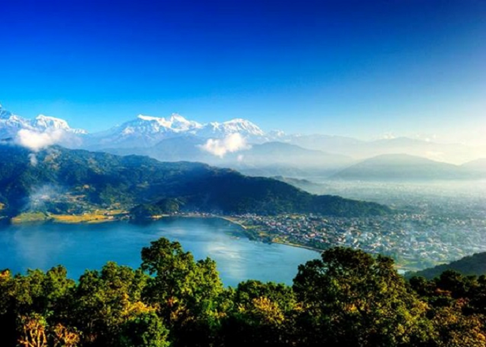 Considered Nepal’s most picturesque destination, Pokhara is located in a tectonically active valley surrounded by the Himalayan and Mahabharat Mountain Ranges. The Seti River and tributaries flow from these mountains and freshwater lakes are located throughout the city. The same geological features that contribute to Pokhara’s natural beauty cause its volatility. The United Nations Development Programme ranks Nepal 11th in the world for its susceptibility to natural disasters that include earthquakes, floods, landslides, drought, and sinkholes.
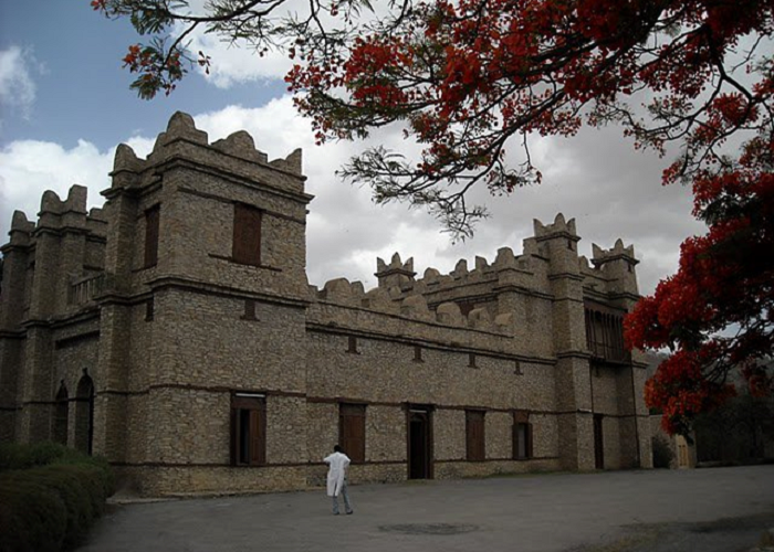 Mekelle is the capital city of the Tigray Regional State of Ethiopia. It is one of the principal economic, cultural, political, and educational centers of the country. Mekelle is known for the cultural landmarks that include Ethiopian Orthodox churches and historic castles. Climate extremes are characteristic of the region. Mekelle is experiencing severe water problems that include lack of an adequate supply and quality issues.
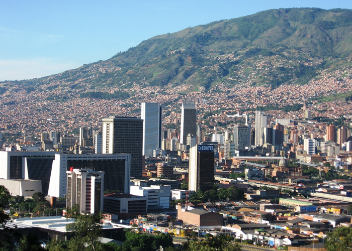 Medellin is the capital of the mountainous Antioquia province of Colombia. The metropolitan area of Medellin includes nine other cities and is the second largest urban agglomeration in the country. Medellin is a hub of economic, education and cultural activity and at the forefront of urban development for innovation, livability, and urban sustainability. Rapid urban growth and migration have created challenges for future planning.
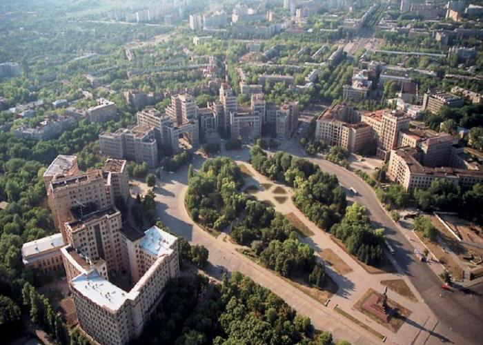 Kharkiv was founded in 1654 as a small fortress that grew to become a major center of Ukrainian culture within the Russian Empire. The city functioned as the first capital of the Ukrainian Soviet Socialist Republic until 1935, after which the capital was relocated to Kiev. Kharkiv is the administrative center of Kharkiv Oblast and of the surrounding Kharkiv district. The city’s population is the second largest in Ukraine. Although the majority of the population is Ukrainian both in nationality and ethnicity, Kharkiv’s largest minority is of Russian descent due to its history and proximity to Russia.
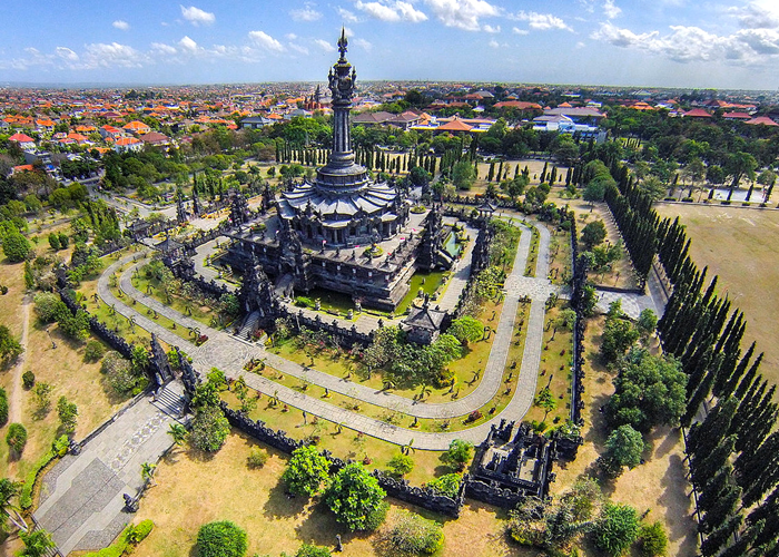 Denpasar is the capital of Bali island and has the highest growth rate in Bali Province where tourism has expanded massively in recent years. The city is a hub for other cities in eastern Indonesia. Due to development pressures, Denpasar has experienced rapid physical, economic, and cultural change. Informal growth and the expanding tourist industry have fueled significant problems for waste management, particularly ocean trash.
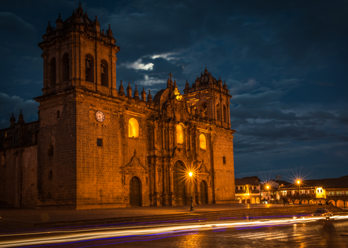 Cusco is located in the highlands of southeastern Peru at an elevation of 3,400 meters. It is the capital of the Cusco region and province, and has an estimated population of more than 435,000. From the 13th – 16th C, the city was capital of the Incan Empire, which led to its designation as a UNESCO World Heritage Site. It serves as a gateway to the famous ruins of Machu Picchu, making it a renowned global tourist destination. In recent decades, Cusco has experienced rapid urban growth and land use displacement, especially in the higher elevation districts of Santiago, San Sebastian and San Jeronimo. These locations are particularly susceptible to earthquakes, landslides, and flooding.